| Geographical and Historical Background 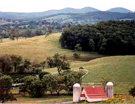
| The Piedmont "Piedmont" means foothills, and in Virginia it refers to the foothills of the Blue Ridge Mountains. The Northern Virginia Piedmont stretches along the eastern slope of the Blue Ridge, from the rural outskirts of Washington, D.C. in the north to Charlottesville in the south, near Thomas Jefferson's hilltop home, Monticello. The Blue Ridge was formed about 400 million years ago, pushed upward into towering mountain peaks when Africa crashed into North America. Today the Blue Ridge is a system of low hills, mountains, and plateaus. Soil and rock deposits from millions of years of erosion created a place where human life would find the necessities of water, food, and shelter within the long folds of valleys and mountain ridges. The temperate climate, abundant water, and fertile soils supported later generations who turned to agriculture for sustenance, setting a pattern of village and commercial settlements among farmland. This pattern of land use continues today. |
The John Singleton Mosby Heritage Area The Mosby Heritage Area is one of over 100 Heritage Areas formed by Americans throughout the country to celebrate their own communities' distinctive characters and senses of place. In 1995, local citizens established the boundaries for the Mosby Heritage Area along natural features and historic travelways and received official support through resolutions passed by the Boards of Supervisors from both Fauquier and Loudoun Counties. The Mosby Heritage Area is a "living museum" and retains much of the landscape and landmarks of the past three centuries. The Area is named for Colonel John Singleton Mosby, whose Rangers so dominated the region during the Civil War that its core was known as Mosby's Confederacy. The Route 50 Corridor bisects the John Mosby Heritage Area. The Rural Route 50 Corridor Route 50, also known as the John Mosby Highway, is a significant historic transportation corridor. Native Americans first created the path as they followed game from the Potomac River to the Shenandoah Valley. English settlements in coastal Virginia expanded westward in the 1600s and 1700s, and the trail became a more clearly defined road as travelers on horseback, in stage coaches, and in wagons journeyed from the river ports of Alexandria and Georgetown to Winchester in the valley for trade. The small agricultural settlements along the road provided lodging and provisions for travelers and commerce centers for local farmers. The road later served as an important travelway during the Civil War and was the site of significant battles and skirmishes. In addition to the traditional farm landscape, the communities along and around the road are largely comprised of 18th and 19th century architecture that has survived, now inhabited by families and thriving businesses. They include houses, shops, mills, and inns. In 1806, the Little River Turnpike Company opened 34 miles of "paved" road from Alexandria to Aldie and the Aldie-Ashby's Gap Turnpike Company was formed four years later to operate a toll road westward to the crest of the Blue Ridge. In 1922, the Little River Turnpike and Ashby's Gap Turnpike were taken over by the Commonwealth of Virginia and became US Route 50, linking Washington, DC with St. Louis, Missouri, and the West. Communities Connected by Rural Route 50 Within the John Mosby Heritage Area, Route 50 travels through three communities: Aldie, Middleburg, and Upperville. These settlements are brimming with history, character, and their own brand of commercial vitality. Along the stretches of the John Mosby Highway that connect the communities are small hamlets and agricultural tracts that have their own distinguishing characteristics, reflect a large share of the local history, and play an important role in today's rural economy. 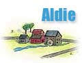 In 1810, Charles Fenton Mercer established a town on 30 acres that he had set aside, including the site of his mill. He named the town after the family's Aldie Castle in Perthshire, Scotland. That year, a stone arch bridge, which is still in use today, was built over Little River. The town grew up around the mill to include three churches, a brick mill, a variety of other small industries, and substantial houses such as Berkeley House, Aldie, Tyler House, and Narrowgate. In 1810, Charles Fenton Mercer established a town on 30 acres that he had set aside, including the site of his mill. He named the town after the family's Aldie Castle in Perthshire, Scotland. That year, a stone arch bridge, which is still in use today, was built over Little River. The town grew up around the mill to include three churches, a brick mill, a variety of other small industries, and substantial houses such as Berkeley House, Aldie, Tyler House, and Narrowgate.
At the west end of town, the road divided, with the Snicker's Gap Turnpike heading northwest and the Ashby's Gap Turnpike continuing due west. Both of the gaps were important passageways through the Blue Ridge to the Shenandoah Valley during the Civil War. The Battle of Aldie is known among historians as one of the significant events leading up to Gettysburg. Mercer's mill still stands, known today as the Aldie Mill, and has been impeccably restored. The tollhouse at the old Snicker's Gap Turnpike, now the Snickersville Turnpike, was converted to a residence. Aldie is characterized by antique shops, a quiet footpath that leaves town near the firehouse and follows the mill race, accommodations at the Little River Inn, a flea market most weekends, and the Aldie General Store with Doc's roadside outdoor barbecue.  In 1728, Joseph Chinn opened an "ordinary" to provide food and lodging, where travelers could stop at the halfway point between Alexandria and Winchester (hence, Middleburg). People settled around the tavern in a small hamlet and called it Chinn's Crossroads. When he inherited 3,300 acres from his father, Chinn sold 500 to Levin Powell, who laid out and incorporated a town of 70 half-acre lots in 1787. Rather than selling the lots Powell leased them, stipulating that each tenant build a house at least 16 feet square, with a stone or brick chimney, within one year. In 1728, Joseph Chinn opened an "ordinary" to provide food and lodging, where travelers could stop at the halfway point between Alexandria and Winchester (hence, Middleburg). People settled around the tavern in a small hamlet and called it Chinn's Crossroads. When he inherited 3,300 acres from his father, Chinn sold 500 to Levin Powell, who laid out and incorporated a town of 70 half-acre lots in 1787. Rather than selling the lots Powell leased them, stipulating that each tenant build a house at least 16 feet square, with a stone or brick chimney, within one year.
Chinn's Crossroads became Middleburg and by 1836 had grown to a population of 436, with 70 dwellings, seven stores, two churches, four schools, two hotels, and a number of small workshops. During the Civil War, Middleburg was the site of significant action. After the Second Battle of Manassas, 1200 wounded men were hauled by wagon over rough roads to Middleburg, where the Free Church and the Methodist Church both had been converted into hospitals and townspeople were taking wounded into their homes and providing tent sites in their yards. At Mt. Sharon Cemetery, Middleburg erected one of the first memorials in the country to honor unknown war casualties. Today, most of the original structures in Middleburg are still in use, and Chinn's Ordinary, which has been operating continuously since its opening, is now the famous Red Fox Inn. Middleburg has long been a destination to people from all over the world who appreciate the area's thriving equine industry. The Historic District of the Town of Middleburg has been designated a Virginia Historic Landmark.  In the 1760s, young George Washington surveyed much of the area west of Middleburg and bought a tract with a stone house that operates today as the Blackthorne Inn & Restaurant.
By 1790, Josephus Carr had assembled 177 acres along Pantherskin Creek, where he established a village of 50 lots called "Carrstown." Founded in 1797, Carrstown was renamed Upperville, for reasons still unknown, by the 1818-1819 Virginia General Assembly. Like Aldie, Upperville thrived because of its location near a creek that could turn millstones for grinding corn and wheat. Upperville is affectionately called the town that is "a mile long and an inch wide" because most of the houses line Columbia Street, as Route 50 was called on the original plat. In the 1760s, young George Washington surveyed much of the area west of Middleburg and bought a tract with a stone house that operates today as the Blackthorne Inn & Restaurant.
By 1790, Josephus Carr had assembled 177 acres along Pantherskin Creek, where he established a village of 50 lots called "Carrstown." Founded in 1797, Carrstown was renamed Upperville, for reasons still unknown, by the 1818-1819 Virginia General Assembly. Like Aldie, Upperville thrived because of its location near a creek that could turn millstones for grinding corn and wheat. Upperville is affectionately called the town that is "a mile long and an inch wide" because most of the houses line Columbia Street, as Route 50 was called on the original plat.
Trinity Episcopal Church is a centerpiece of the Upperville community. The church was built of local sandstone by craftsmen of the nearby countryside. Oakley Farm, one of Upperville's most historic places, was the scene of two Civil War battles. Ida Dulaney, the owner of Oakley during the war, recalls in her diary that she stood on her balcony watching the armies charge and countercharge through her grounds. The balcony at Oakley still overlooks those same fields which remain unchanged. The Upperville Colt and Horse Show, first organized in 1846 by Richard H. Dulaney of nearby Wellbourne, is the second oldest continuously running sporting event in the United States and is still held on the same grounds, which straddle Route 50. The entire town of Upperville is a Virginia Historic Landmark and is listed in the National Register of Historic Places.
 A few miles west of Upperville, the tiny village of Paris is nestled in the eastern slope of the Blue Ridge below Ashby's Gap. Paris was formally named in 1819 in honor of the home of the Marquis de Lafayette, an ardent supporter of the American Revolution. The view across the Piedmont landscape from the crest of Ashby's Gap is deservedly considered one of Virginia's most beautiful. The village and surrounding countryside have changed little over the past two centuries. A few miles west of Upperville, the tiny village of Paris is nestled in the eastern slope of the Blue Ridge below Ashby's Gap. Paris was formally named in 1819 in honor of the home of the Marquis de Lafayette, an ardent supporter of the American Revolution. The view across the Piedmont landscape from the crest of Ashby's Gap is deservedly considered one of Virginia's most beautiful. The village and surrounding countryside have changed little over the past two centuries.
Between and Beyond the Communities The Rural Route 50 corridor between and beyond the three communities is particularly scenic and historic, with period structures and unspoiled landscape. From Lenah to Paris, the Route 50 corridor constitutes an area which, because it has remained largely unchanged, is of notable economic value to Fauquier and Loudoun Counties for the wages and revenue generated by the horse industry, agriculture, and tourism. At the east end of the historic corridor stands the red brick Mount Zion Old School Baptist Church, built in 1851. During the Civil War, Mt. Zion Church played may roles: battleground, hospital, prison, barracks, and burial ground. From the end of the war until 1980, regular church services continued. The trustees of the church have maintained it as an historic site and have received a federal grant for its restoration. West of the church are traces of the old Carolina Road, once the principal north-south Indian trail from New York to the Carolinas, which became a major trading route, referred to by some as the Rogues' Road because it was used by gun runners and cattle thieves. Starting just west of Aldie and heading northwest for fourteen miles to Snicker's Gap, the Snickersville Turnpike is another important historic corridor. The Battle of Aldie took place about a mile and a half up the Turnpike, culminating in a bloody cavalry encounter which is still marked by a roadside monument erected in 1880 by survivors of the 1st Massachusetts Cavalry, the only Union monument that stands on southern soil. Halfway to the gap, the Turnpike crosses Beaverdam Creek over Hibbs Bridge, a masonry arch bridge built around 1820 by the same stonemasons who built the stone bridge in Aldie. Citizens organized in 1994 to protect both the Turnpike and Hibbs Bridge. 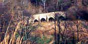 The Goose Creek Stone Bridge took the old Ashby's Gap Turnpike (Route 50) over Goose Creek just beyond its confluence with Pantherskin Creek between Middleburg and Upperville. Spanning 200 feet with four arches, this structure is the longest of the remaining stone arch turnpike bridges in Northern Virginia. The Fauquier-Loudoun Garden Club undertook maintenance of the bridge as a Bicentennial project. The Goose Creek Stone Bridge took the old Ashby's Gap Turnpike (Route 50) over Goose Creek just beyond its confluence with Pantherskin Creek between Middleburg and Upperville. Spanning 200 feet with four arches, this structure is the longest of the remaining stone arch turnpike bridges in Northern Virginia. The Fauquier-Loudoun Garden Club undertook maintenance of the bridge as a Bicentennial project.
The Rural Route 50 Corridor Today 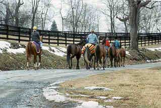 Today, the towns and villages along Rural Route 50 are self-sustaining communities where people live and work and where agriculture is still the leading industry. Some residents commute and telecommute, but many make their living in the towns and on surrounding farms at jobs of all types, including publishing, high technology, consulting, and the professions. The equine industry employs thousands of people as trainers, riders, grooms, caretakers, maintenance workers, and farm managers. Today, the towns and villages along Rural Route 50 are self-sustaining communities where people live and work and where agriculture is still the leading industry. Some residents commute and telecommute, but many make their living in the towns and on surrounding farms at jobs of all types, including publishing, high technology, consulting, and the professions. The equine industry employs thousands of people as trainers, riders, grooms, caretakers, maintenance workers, and farm managers.
The local residents depend on the towns for groceries, postal services, hardware, and other supplies. The number of local people earning and spending their wages in the community, contributes to a sustainable economy. The villages and farms survive economically because the main travel-way passes through the towns as it always has, keeping the center alive and the surrounding farmland unharmed. The Blue Ridge landscape, beautiful scenery, historical roots, peaceful winding country roads, local wineries, antiques shops, inns, and farms surrounding The John Mosby Highway also offer a unique touring experience, including local wine festivals, races, stable tours, and garden tours. Visitors come from a wide range of origins: residents from the city or suburbs who want to get away for a day, vacationing families from all over the US who want to immerse themselves in real history, and visitors from other countries who come to enjoy the unspoiled beauty of the Virginia countryside. The area is also known for its abundant natural resources: wildlife, stream valleys, mountains, and its rich cultural heritage. Rather than displaying historic facades and people in costume, Route 50 connects authentic communities -- the kind of communities where families want to make their homes and tourists enjoy visiting. There is an intensely felt need on the part of the community and those who visit it to preserve this countryside. Return to top of page |